|
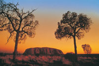
Uluru also known as Ayers
Rock in Central Australia
|
|
Uluru-Kata Tjuta National Park is a world-class visitor
destination and a key part of Australia's iconic Red
Centre. This living cultural landscape is the physical
and metaphoric heart of Australia, and was one of the
first areas to be identified as a National Landscape.
Ayres rock Uluru, also referred to as Ayers Rock, is
a large sandstone rock formation in the southern part
of the Northern Territory, central Australia. It lies
335 km (208 mi) south west of the nearest large town,
Alice Springs; 450 km (280 mi) by road. Kata Tjuta (The
Olgas) and Uluru are the two major features of the Uluru
- Kata Tjuta National Park. Uluru is sacred to the Pitjantjatjara
and Yankunytjatjara, the Aboriginal people of the area.
More
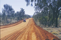
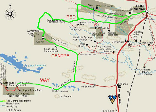
on Mereenie Loop Road - About Mereenie Loop Road
More
on Kata Tjuta
More
on Kings Canyon
More
on Alice Springs
Uluru Kata Tjuta National Park
Uluru
Kata Tjuta National Park
Uluru
Ayers Rock
Ayers
Rock Resort at Yulara
Voyages
Resort at Ayers Rock Resort, Yulara
Ayers-Rock-Airport-Connellan
Kata-Tjuta-The-Olgas
Sounds-of-Silence-dinner
|
|
|
|
Uluru, also known as Ayers Rock
Welcome to Aboriginal land
Pukulngalya yanama, Ananguku Ngurakutu (welcome
greeting in Yankunytjatjara)
Pukulpa Pitjama, Ananguku Ngurakutu
(welcome greeting in Pitjantjatjara)
The traditional land owners of Uluru-Kata Tjuta
National Park, are direct descendants of the beings
who created our lands during the Tjukurpa (Creation
Time). We have always been here. We call ourselves
Anangu, and would like you to use that term for
us.
Uluru-Kata Tjuta National Park is a world-class
visitor destination and a key part of Australia's
iconic Red Centre. This living cultural landscape
is the physical and metaphoric heart of Australia,
and was one of the first areas to be identified
as a National Landscape.
Ayres rock Uluru, also referred to as Ayers Rock,
is a large sandstone rock formation in the southern
part of the Northern Territory, central Australia.
It lies 335 km (208 mi) south west of the nearest
large town, Alice Springs; 450 km (280 mi) by
road. Kata Tjuta (The Olgas) and Uluru are the
two major features of the Uluru - Kata Tjuta National
Park. Uluru is sacred to the Pitjantjatjara and
Yankunytjatjara, the Aboriginal people of the
area.
It has many springs, waterholes, rock caves
and ancient paintings. Uluru is listed as a World
Heritage Site. The local Pitjantjatjara people
call the landmark Uluru . This word has no particular
meaning in their dialect, also known as Pitjantjatjara,
but it is also used as a local family name by
the senior Traditional Owners of Uluru.
On 19 July 1873, the surveyor William Gosse visited
Uluru and named it Ayers Rock in honour of the
then-Chief Secretary of South Australia, Sir Henry
Ayers. Since then, both names have been used,
although Ayers Rock was the most common name used
by outsiders until recently. In 1993, a dual naming
policy was adopted that allowed official names
that consist of both the traditional Aboriginal
name and the English name.
On 15 December 1993, it was renamed "Ayers Rock/Uluru"
and became the first officially dual-named feature
in the Northern Territory. The order of the dual
names was officially reversed to "Uluru/Ayers
Rock" on 6 November 2002 following a request from
the Regional Tourism Association in Alice Springs.
Uluru is one of Australia's most recognisable
natural icons. The world-renowned sandstone formation
stands 348 m (1,142 ft) high (863 m/2,831 ft above
sea level) with most of its bulk below the ground,
and measures 9.4 km (5.8 mi) in circumference.
Uluru is notable for appearing to change colour
as the different light strikes it at different
times of the day and year, with sunset a particularly
remarkable sight when it briefly glows red. Although
rainfall is uncommon in this semiarid area, during
wet periods the rock acquires a silvery-grey colour,
with streaks of black algae forming on the areas
that serve as channels for water flow. Uluru is
an inselberg, literally "island mountain", an
isolated remnant left after the slow erosion of
an original mountain range. Uluru is also often
referred to as a monolith, although this is a
somewhat ambiguous term because of its multiple
meanings, and thus a word generally avoided by
geologists.
The strata at Uluru are nearly vertical, dipping
to the south west at 85°, and have an exposed
thickness of at least 2,400 m (7,900 ft). The
strata dip below the surrounding plain and no
doubt extend well beyond Uluru in the subsurface,
but the extent is not known.
Cultural Centre
When you visit Uluru - Kata Tjuta National Park,
you should ensure that you explore the Cultural
Centre first. You will enjoy exploring the Park
much more if you understand Anangu culture and
this very special cultural and natural environment.
At the Cultural Centre you can get an introduction
to Tjukurpa (law, knowledge, religion, philosophy),
Anangu art, Anangu way of life (traditional and
current), history, languages, wildlife and joint
management of the Park. The displays feature photo
collages, oral history sound panels, Pitjantjatjara
language learning interactives, soundscapes, videos
and artefacts. There are bush tucker sessions,
plants walks and cultural sessions for visitors
to experience. Cultural Centre notes are provided
in Pitjantjatjara, English, Italian, Japanese,
German and French. A touch wall for visually impaired
people ensures that the messages are accessible
to everyone. Daily schedules vary, so ask at the
Cultural Centre Information Desk.
Park
Fees
|
 |
| |
 |
 |
 |
 |
 |
|
|
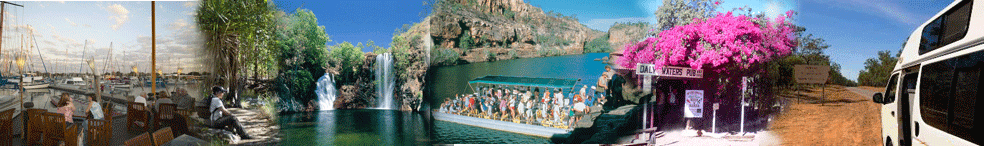
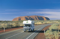
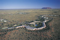
Ayers Rock Resort
Regardless of where you stay while you're at
Voyages Ayers Rock Resort, from the sanctuary
of one of the five hotels, or the intimacy of
Voyages Ayers Rock Resort Campground, you can
experience the beauty of the living cultural landscape
of Uluru-Kata Tjuta National Park, in Australia's
Northern Territory. With over 65 tours, local
activities and attractions within the Resort and
the Uluru-Kata Tjuta National Park, your days
will be action-packed. Ride a camel across the
desert dunes. Hop on a Harley, or embark on a
base walk of Uluru (Ayers Rock).
Getting There
Ayers Rock Resort Airport Fly direct to the heart
of Australia ... You can fly daily from Perth,
Sydney, Cairns and Alice Springs direct to Ayers
Rock Airport. Direct flights operate twice a week
from Melbourne. Flights from Darwin and Brisbane
connect from Alice Springs through to Ayers Rock
Airport. Ayers Rock Airport is conveniently located
just six kilometres from Voyages Ayers Rock Resort
(10 minutes' travel). The airport services both
fixed and rotary winged aircraft and receives
up to on average 350,000 - 400,000 commercial
passengers per year. It's also a popular stopping
off point for private pilots and passengers travelling
in their own aircraft. From Ayers Rock Airport,
you can enjoy scenic desert flights over Uluru
and Kata Tjuta. You will find hire car companies,
tour desks, a Qantas desk, Ayers Rock Design retail
outlet, and an information desk at the airport.
Airport Transfers - Complimentary return coach
transfers from Ayers Rock Airport to Voyages Ayers
Rock Resort meet every scheduled flight. The return
transfer to Ayers Rock Resort Airport collects
you from your hotel approximately 2 hours prior
to flight departure please check with reception
for exact time. http://www.ayersrockresort.com.au/
|
|
| |
|
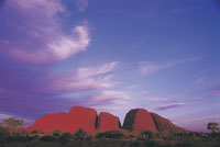
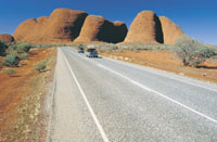
| Kata Tjuta (The
Olgas)
Both Uluru and Kata Tjuta have great cultural
significance for the Anangu Traditional landowners,
who lead walking tours to inform visitors about
the local flora and fauna, bush foods and the
Aboriginal dreamtime stories of the area.
Kata Tjuta, also called Mount Olga or The Olgas
owing to its peculiar formation, is another rock
formation about 25 km (16 mi) from Uluru. Special
viewing areas with road access and parking have
been constructed to give tourists the best views
of both sites at dawn and dusk.
The rock was originally sand, deposited as part
of an extensive alluvial fan that extended out
from the ancestors of the Musgrave, Mann and Petermann
Ranges to the south and west, but separate from
a nearby fan that deposited the sand, pebbles
and cobbles that now make up Kata Tjuta. The similar
mineral composition of the Mutitjulu Arkose and
the granite ranges to the south is now explained.
|
 |
 |
|
|
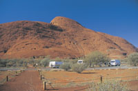
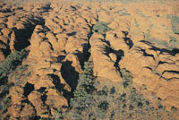
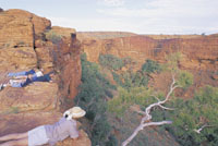
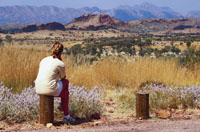
Kings Canyon in Watarrka National Park
Voyages Kings Canyon Resort is located in a loop
off the main highway running between Ayers Rock
and Alice Springs. The sensitively designed resort
is just seven kilometres from Watarrka National
Park, the home of the magical sandstone formation
of Kings Canyon.
Due to Voyages commitment to best environmental
practice, the resort has been built to blend harmoniously
with the surrounds. Kings Canyon Resort offers
a wide range of accommodation from the campground
that enjoys the outdoor stillness of the Red Centre
to deluxe spa rooms - offering understated comfort
rather unexpected in such a remote location.
It is the perfect oasis from which to explore
the wonders of Kings Canyon including the amazing
rock formation called the Lost City and the Garden
of Eden an oasis of an entirely different kind
at the foot of the Canyon. The flora of Kings
Canyon offers a clear indication that the climate
of this whole area was once vastly different.
Getting There
There is no better way to explore Central Australia
then at your own pace. As Kings Canyon lies just
3 hours from Uluru (Ayers Rock) and approx. 4
hours from Alice Springs, self drive is a popular
option. The drive passes some incredible sites
including Standley Chasm, Ellery Creek and Ormiston
Gorge.
The Mereenie Loop Road brings you right to the
doorstep of the Resort. Please note: the Mareenie
Loop Road is an unsealed road for 197km of 337km,
a 4WD is required. Alternatively travel via the
Stuart Highway, approx. distance from Alice Springs
to Kings Canyon 461km and 4.5 hours travelling
time.
http://www.kingscanyonresort.com.au/
|
 |
 |
 |
|
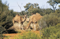
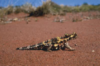
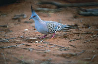
| Flora
and Fauna in Uluru Kata Juta National Park
Anangu acknowledge that a decrease in the number
has implications for the condition and health
of the landscape. Moves are supported for the
reintroduction of locally extinct animals such
as Malleefowl, Common Brushtail Possum, Rufous
Hare-wallaby or Mala, Bilby, Burrowing Bettong
and the Black-flanked Rock-wallaby.
The Mulgara, the only mammal listed as vulnerable,
is mostly restricted to the transitional sand
plain area, a narrow band of country that stretches
from the vicinity of Uluru to the Northern boundary
of the park and into Ayers Rock Resort. This area
also contains the marsupial mole, Woma Python
and Great Desert Skink. The bat population of
the park comprises at least seven species that
depend on day roosting sites within caves and
crevices of Uluru and Kata Tjuta. Most of the
bats forage for aerial prey within 100 m (330
ft) or so from the rock face.
The park has a very rich reptile fauna of high
conservation significance with 73 species having
been reliably recorded. Four species of frog are
abundant at the base of Uluru and Kata Tjuta following
summer rains.
The Great Desert Skink is listed as vulnerable.
Anangu continue to hunt and gather animal species
in remote areas of the park and on angu land elsewhere.
Hunting is largely confined to the Red Kangaroo,
Bush Turkey, Emu and lizards such as the Sand
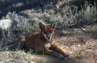
Goanna and Perentie. Of the 27 mammal species
found in the park, six are introduced: the House
Mouse, camel, fox, cat, dog and rabbit. These
species are distributed throughout the park but
their densities are greatest in the rich water
run-off areas of Uluru and Kata Tjuta. Uluru -
Kata Tjuta National Park flora represents a large
portion of plants found in Central Australia.
A number of these species are considered rare
and restricted in the park or the immediate region.
There are many rare and endemic plants at Uluru
and Kata Tjuta. The growth and reproduction of
plant communities rely on irregular rainfall.
Some plants are able to survive fire and some
are dependent on it to reproduce.
Plants are an important part of Tjukurpa, and
there are ceremonies for each of the major plant
foods. Many plants are associated with ancestral
beings.
Trees such as the Mulga and Centralian Bloodwood
are used to make tools such as spearheads, boomerangs
and bowls. The red sap of the bloodwood is used
as a disinfectant and an inhalant for coughs and
colds. There are several rare and endangered species
in the park. Most of them, like Adder's
Tongue ferns, are restricted to the moist areas
at the base of the formation, which are areas
of high visitor use and subject to erosion. Since
the first Europeans arrived, 34 exotic plant species
have been recorded in the park, representing about
6.4% of the total park flora.
Some, such as perennial buffel grass (Cenchrus
ciliaris), were introduced to rehabilitate areas
damaged by erosion. It is the most threatening
weed in the park and has spread to invade water-
and nutrient-rich drainage lines. A few others,
such as burrgrass, were brought in accidentally,
carried on cars and people.
|
|
 |
 |
 |
 |
|
| |
 |